 Chinese
Welcome to the official website of the Chinese Academy of Meteorological Sciences
Chinese
Chinese
-
 Date 2024-04-28
Chinese

一、The
purpose of the third atmopheric testing in Tibetan Plateau
The environment in Tibetan Plateau is very severe and there lack common meteorological stations and observation materials, and the remote-sensing materials are very uncertain. Such facts are directly affecting the development of meteorology of Tibetan Plateau. The numerical mode has become the main measure of climate and weather forecasting, however, because of the unique boundary layer structure and complex physical procedure of cloud precipitation in Tibetan Plateau, nearly all the numerical modes have low simulation capabilities to the climate in Eastern Asia, especially for plateau cloud and precipitation, and they are directly restraining the promotion of accuracy rate of numerical forecasting.
Under the supporting of National Science and Technology Committee and National Planning Committee, China Academy of Science and Central Meteorological Administration performed the first atmospheric scientific testing in Tibetan Plateau in May-August, 1979.Under the supporting of Ministry of Science and Technology,China meteorological administrationandChinese Academy of Sciencesper formed the second atmospheric scientific testing in Tibetan Plateau in May-August, 1998, and the two tests centered on the land-air mutual effects in Tibetan Plateau and the observation on boundary layer and performed the deep and detailed research, and they have provided the precious experiences for the atmospheric scientific testing in Tibetan Plateau.
二、The third atmopheric testing plan in Tibetan Plateau
China meteorological administration,National Natural Science Foundation of China andChina Academy of Science
promoted the project approval for the third atmopheric testing plan in Tibetan Plateau in 2013. This project performed
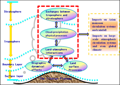
the research on the critical scientific and technologic problems to the mutual
effects of the unique land surface – boundary layer – troposphere –
stratosphere in Tibetan Plateau. It includes the technology of incorporation
and comprehensive analysis of multi-source observation information, the effect
of multi-scale terrain in plateau and the physical procedure in land surface –
boundary layer, the physical procedure of cloud precipitation in plateau and
the atmospheric water circulation, the physical and chemical procedure of
exchange between stratosphere and troposphere in the plateau, the comprehensive
diagnosis and forecasting methods of the climate system in plateau and the disasters it causes, the affecting
mechanism of abnormal climate in plateau and the predicting methods, etc.
Therefore, the scientific testing lasting for 8-10 years will perform the 3D
comprehensive field observation and the research on scientific theory and
technology from land surface to stratosphere.
三、The general thought of design
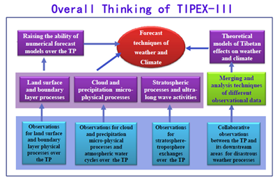
The third atmopheric testing in Tibetan Plateau will be centered on the critical technology on forecasting the disastrous weather and climate of China, and it will construct the 3D comprehensive observation system on points and surfaces in Tibetan Plateau and surrounding areas, and realize the sky-based, space-based and land-based integrated observation to the land surface, boundary layer, stratosphere and troposphere of the plateau and realize the long-term observation gradually; it will sufficiently utilize the historical information, the current operational system, the information of observation and remote-sensing in the middle and western part of the plateau provided by the operational observation stations constructed during the 12thFive-year Plan as well as the information of intensive observation during the testing, so as to increase the accuracy of satellite inversion products in the plateau area and develop the incorporating analysis technology on the ground, sky and satellite remote-sensing; it will establish the physical procedure model on land surface-boundary layer and for cloud precipitation under the complex terrain of plateau as well as the parameterization technology of relevant numerical forecasting mode; it will raise the new recognition of Tibetan Plateau’s effect on the disastrous weather and extreme weather events in China, develop the technology of disastrous weather forecasting in Tibetan Plateau and the lower reach as well as the short-term climate prediction for the extreme climate events and provide the technical support for increasing the operational capabilities of rainstorm, draught and flooding forecasting in China.
四、The arrangement of field observation during the testing
The first phase: 2014-2017 Year
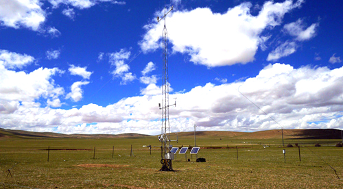
The observation of the procedures in boundary layer(Xizang,Sichuan,Yunnan)
The observation of the physical procedure of cloud precipitation(Xizang,Sichuan,Yunnan)
The comprehensive observation of atmospheric and water circulation in Tibetan Plateau
The comprehensive for the verification of satellite remote-sensing products in Tibetan Plateau
The second phase: 2018-2021 Year
The observation of boundary layer(Qinghai,Gansu,Shaanxi)
五、 The researching tasks of the testing
The comprehensive application platform for research achievements

Address:46, Zhong-Guan-Cun South Avenue Haidian District Beijing 100081, China
Zip code: 100081 Telephone:010-68406206
Total traffic:
京ICP备15006967号-1(http://www.beian.miit.gov.cn)

 Current location :