 English
欢迎访问中国气象科学研究院官方网站
English
English

-
 时间 2026-09-09


来源:CGTN
近日发生在中国尼泊尔边境由冰岩崩引发的泥石流灾害,再次让人们将目光投向冰川。
冰川常被视为全球变暖的“受害者”,但其消融退缩、冻土退化和冰湖扩张,也可能与极端天气、复杂地质条件等共同增加冰崩、冰湖溃决、滑坡和泥石流等灾害风险。
A geological disaster that recently struck along the China-Nepal border has once again drawn attention to glaciers.
Glaciers are often seen as "victims" of global warming. But glacier retreat, permafrost degradation and the expansion of glacial lakes, combined with extreme weather and complex geological conditions, may also increase the risks of ice avalanches, glacial lake outbursts, landslides and debris flows.
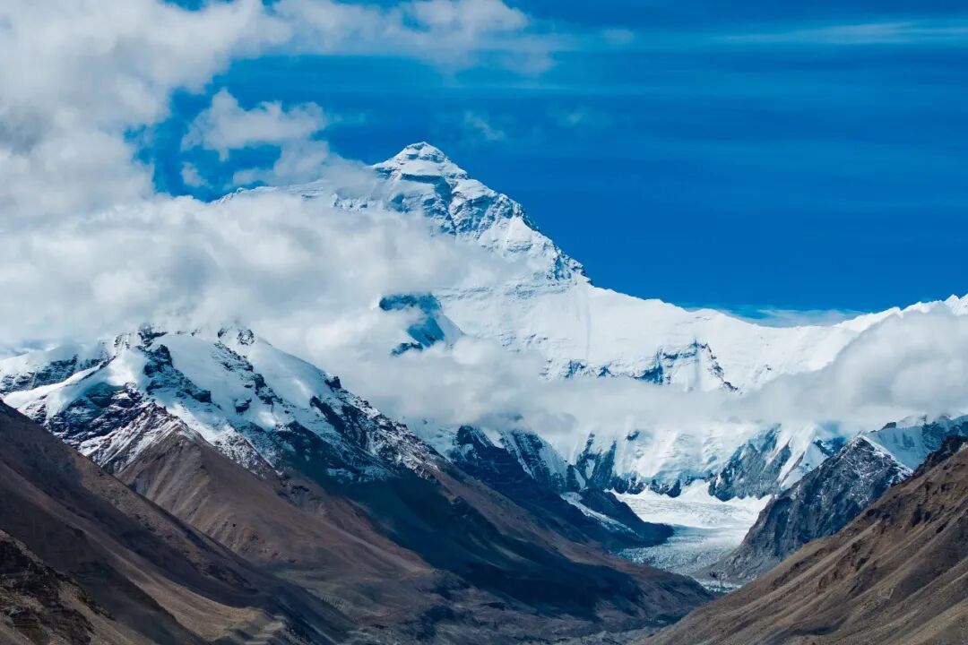
中国与尼泊尔边境的喜马拉雅山脉中段。图片来源:视觉中国
近年来,极端天气气候事件监测预警技术不断进步,分布在人迹罕至高山地区的冰川能否实现预警?围绕冰川灾害、气候变化与监测预警等问题,中国气象科学研究院全球变化与极地研究所研究员张东启和国家气候中心气候变化监测预估室正研级高级工程师马丽娟接受CGTN采访。
As monitoring and early warning technologies for extreme weather and climate events continue to advance, can glaciers in remote, high-altitude areas be monitored and warnings issued before disasters occur?
CGTN spoke with two experts about glacial disasters, climate change, monitoring and early warning: Zhang Dongqi, a research scientist at the Chinese Academy of Meteorological Sciences' Institute of Global Change and Polar Meteorology, and Ma Lijuan, a research scientist at the National Climate Centre's Division of Climate Change Monitoring and Projection.
CGTN:冰岩崩以及其他冰川相关灾害的发生频率或严重程度是否正在增加?卫星和其他技术进步是否也让我们发现了过去没有发现的灾害?
CGTN: We often think of glaciers as victims of climate change. Are we now also seeing glaciers becoming sources of hazard? Are ice-rock avalanches and other glacier-related hazards becoming more frequent or more severe?
Zhang Dongqi: Glacial disasters have always existed. They occurred less frequently during periods of stable climate and consequently attracted less attention. Against the backdrop of global warming, glacial disasters are becoming more frequent, causing greater losses and drawing increasing attention.
Analysis of the past several decades, or even the past 10 to 20 years, shows that ice-rock avalanches and other glacier-related disasters have indeed been increasing in frequency, and their severity is also increasing. Both factors are at play. Global warming has led to a higher incidence of cryospheric disasters in recent decades.
The expansion of human activity, advances in satellite remote sensing and other monitoring methods have also enabled us to detect more disasters in remote areas, including some that did not cause casualties in the past but left clear traces.
马丽娟:在全球气候系统变暖背景下,以青藏高原为核心的亚洲高山区冰川消融退缩、冻土退化、积雪减少,且20世纪90年代以来呈加剧态势,导致冰川失稳、冰湖数量和面积增大。2010年代以来已观测到亚洲高山区冰冻圈灾害事件增多,冰/雪崩、冰湖溃决、冰川泥石流、融雪型洪水等灾害发生频率加大。研究表明,至少自1950年以来冰川崩塌事件增多,1970年以来热融湖塘数量上升、热融滑塌和热融沉陷事件增多。自2015年以来,在亚洲高山区大范围内持续观测到冰冻圈灾害事件。
我国目前已经完成三次冰川编目:第一次1978-2002年期间,第二次2008-2015年,第三次2023-2026年,综合评估结果显示,青藏高原冰川面积从5.1万下降到4.4万,再到3.9万平方千米。根据第二次青藏高原综合科学考察结果,1990-2020年,青藏高原冰湖数目和面积增长率均超过20%。
Ma Lijuan: Against the backdrop of a warming climate, glaciers in High Mountain Asia, with the Qinghai-Xizang Plateau as the core region, have been retreating and losing mass, while permafrost has been degrading and snow cover has been decreasing, with these trends intensifying since the 1990s. This has led to glacier instability and increases in the number and area of glacial lakes.
Cryosphere-related disasters, such as ice and snow avalanches, glacial lake outbursts, glacier-related debris flows and snowmelt floods have occurred more frequently. Studies show that glacier collapse events have increased since at least 1950, while the number of thermokarst ponds and the occurrence of permafrost retrogressive thaw slump have increased since the 1970s. Since 2015, abrupt cryosphere events have been continuously observed across large areas of High Mountain Asia.
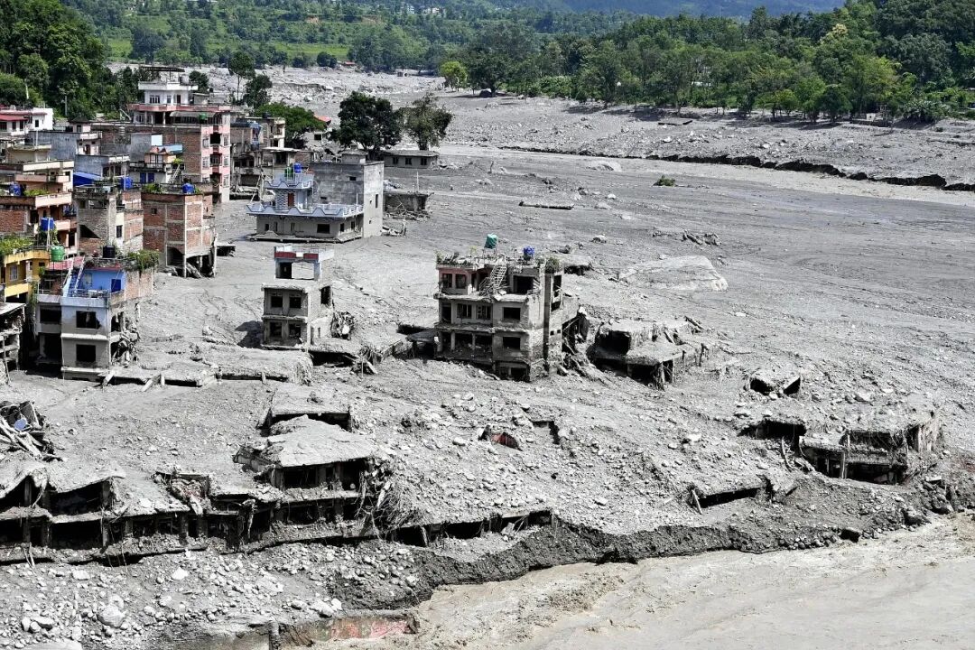
8月28日,尼泊尔比杜尔,博特科西河支流沿岸一处遭大规模泥石流袭击的灾害现场。图片来源:视觉中国
CGTN:气候变暖究竟会如何触发冰川灾难?现在可以下结论说是气候变化导致了这次事件吗?
CGTN: How does a warming climate change the physical conditions that keep glaciers and mountain slopes stable? Can we say that climate change increases the risk of glacier collapse, even if we cannot say it directly caused this particular event?
马丽娟:温度、降水和地形是冰川形成发育的三个必要条件。20世纪60年代以来,青藏高原及周边地区显著增暖,升温速率明显高于同期全球平均水平,高温事件趋多,年降水量亦波动增加,极端性增强。气候变暖造成冰川物质损失加速,冰川活动性加大,内部结构稳定性下降,为冰川跃动和冰崩提供了动力条件。
另一方面冰雪融水导致冰湖数量增多、面积快速扩张,叠加极端温度、极端降水等天气气候事件和松散地质条件,使得冰湖溃决灾害频次增加。
从目前各方调查的信息看,该次事件是冰岩崩率先被触发。气候变化是冰川融化的重要的长期风险因子,本次事件的直接主因是冰川失稳带来的地质环境变化。
Ma: Temperature, precipitation and topography are the three necessary conditions for glacier formation and development. Since the 1960s, the Qinghai-Xizang Plateau and surrounding areas have warmed significantly, with the rate of warming clearly higher than the global average over the same period.
High-temperature events have become more frequent, while annual precipitation has also fluctuated upward, with greater extremes. Climate warming has accelerated glacier mass loss, increased glacier movement and reduced the stability of their internal structures, providing dynamic conditions for glacier surges and ice avalanches.
Meanwhile, glacier meltwater has increased the number of glacial lakes and rapidly expanded their area. Combined with extreme temperatures, extreme precipitation and loose geological conditions, this has contributed to the increased frequency of glacial lake outburst disasters.
Climate change is an important long-term risk factor for glacier melting. The direct cause of this event was geological environmental changes resulting from glacier instability.
CGTN:我们能预测一座冰川或一块冰体什么时候可能崩塌吗?在一次大型冰崩发生之前,科学家会关注哪些信号?
CGTN: Can we predict when a glacier or ice mass is likely to collapse? What signs should scientists be looking for before a major collapse?
张东启:如果布设足够多的监测设备,数据能够及时分析,我们基本可以预测一座冰川有没有发生崩塌的可能性,但预测具体的崩塌时间难度很大。目前看冰川多分布在人迹罕至的高山地区,监测不到位,预测其冰崩的难度非常大。地质、气象等多方面的信号都要进行关注,如该冰川所在地区是否发生过地震、近期是否有持续或者剧烈升温、是否发生过持续或者极端降水等现象?此外,如有监测条件,冰川本身的应力形变等信号需要更加引起关注。
Zhang: If enough monitoring equipment is deployed and the data can be analyzed in a timely manner, we can basically predict whether a glacier has the potential to collapse, but predicting the exact timing of a collapse is very difficult. At present, glaciers are mostly located in remote, high-altitude areas where monitoring is inadequate, making it very difficult to predict ice avalanches.
Signals from multiple aspects, including geological and meteorological factors, need to be monitored, such as whether an earthquake has occurred in the area where the glacier is located, whether there has been sustained or sharp warming recently, and whether there has been prolonged or extreme precipitation. In addition, where monitoring conditions permit, signals such as stress and deformation within the glacier itself require particular attention.
马丽娟:山地冰川分布于高寒气候区和高海拔山区,系统性野外观测难以常态化开展,一手观测数据积累相对薄弱。高新观测技术手段的日益发展,常态化监测正迎来新的契机。但是,要建立完备的预警系统,仍任重道远。需要针对青藏高原复杂地形特征和典型冰川灾害特点,构建区域地球系统协同观测网络,重点强化高风险冰川与冰湖区域的动态监测能力。同时深化典型冰川灾害致灾机理研究,构建综合预警指标体系,预估研判未来演变趋势,科学防范、主动应对高山区冰川变化的影响与灾害风险挑战。近期的灾害事件表明,冰川灾害往往由地震松动山体、冰川退缩、冻土融化、地质条件破碎、持续高温/降水或极端气象条件等因素构成复杂综合致灾链条,且这些因素在长周期内发生耦合,引发大规模链式灾害。上述因素都应该包含在有效的监测预警体系中,实现常态化监测。
Ma: Mountain glaciers are distributed in cold, high-altitude regions, where systematic field observations are difficult to conduct on a regular basis, resulting in relatively limit first-hand observational data. The continued development of advanced observation technologies is creating new opportunities for routine monitoring.
However, establishing a comprehensive early warning system remains a long-term challenge. It is necessary, in light of the complex terrain of the Qinghai-Xizang Plateau and the characteristics of typical glacial disasters, to build a coordinated Earth system observation network, with a focus on strengthening dynamic monitoring of high-risk glaciers and glacial lake areas.
At the same time, research into the disaster-causing mechanisms of typical glacial disasters should be deepened, a comprehensive early warning indicator system established, and future trends assessed and anticipated, so as to scientifically prevent and proactively respond to the impacts and disaster risks posed by changes in high-altitude glaciers.
Recent disaster events show that glacial disasters often result from a complex chain of interacting factors, including earthquakes loosening mountain slopes, glacier retreat, permafrost thaw, fractured geological conditions, prolonged heat or precipitation, and extreme weather and climate conditions. These factors can become coupled over long periods, triggering large-scale cascading disasters. All of these factors should be incorporated into an effective monitoring and early warning system for routine monitoring.
CGTN:技术能够告诉我们哪些关于冰川或山体失稳的信息?一个有效的监测系统现实中能够为下游社区争取多少预警时间?
CGTN: What can satellites and other monitoring technologies tell us about an unstable glacier or mountain slope? How much warning time could an effective monitoring system realistically give communities downstream?
张东启:灾害发生前,遥感或实地监测等技术手段可以给我们提供冰川是否存在失稳的可能性及危险程度等信息;灾害发生后,这些技术可以给我们提供灾害发生的地段、范围、影响程度等信息。不同类型的灾害对应的预警时间有较大差异。在监测系统功能齐全且有效发挥作用的前提下,冰湖溃决的预警时间可能会以天计,但冰崩、雪崩等灾害的预警难度极大,预警时间会大大缩短,可能会在分钟级别。
Zhang: Before a disaster occurs, technologies such as remote sensing and field monitoring can provide information on whether a glacier is potentially unstable and the degree of danger it poses. After a disaster occurs, these technologies can provide information on its location, extent and impact. Different types of disasters allow for very different warning times.
When a monitoring system is fully functional and operating effectively, the warning time for a glacial lake outburst may be measured in days. But ice avalanches and snow avalanches are extremely difficult to warn for, and the warning time may be much shorter, potentially on the order of minutes.
CGTN:目前冰川灾害预警体系最大的短板是什么?
CGTN: What are the biggest gaps in our current early-warning systems?
张东启:监测不到位(包括监测范围小,覆盖不了所有高危冰川;监测手段少,主要依靠卫星遥感资料,缺少实地监测资料)是目前冰川灾害预警体系最大的短板。建议构建多圈层“空-天-地”立体化观测与感知系统,提升灾害的快速捕捉与精准识别能力,为预警提供坚实支撑。
Zhang: Inadequate monitoring – including limited monitoring coverage that cannot cover all high-risk glaciers, and limited monitoring methods that rely mainly on satellite remote sensing data while lacking field monitoring data – is currently the biggest weakness in the early warning system for glacial disasters.
It is recommended that a multi-layered "air-space-ground" three-dimensional observation and sensing system be developed to improve the rapid detection and precise identification of disasters and provide solid support for early warning.
马丽娟:联合国全民早期预警倡议提出预警系统四大要素,包括对灾害风险的认知、监测预测、预警传播与沟通、应急响应。对冰川灾害来讲,这四方面均不成熟,尤其是亟需建立综合监测预测体系。
Ma: The United Nations' Early Warnings for All initiative identifies four key elements of an early-warning system: disaster risk knowledge, monitoring and forecasting, warning dissemination and communication, and preparedness and response. For glacier-related hazards, all four areas remain underdeveloped, and there is an urgent need to establish an integrated monitoring and forecasting system.
 当前所在位置 :
